We are working as an Environmental Consultancy Firm accredited by Bangladesh Accreditation Board (BAB) in the field of Environmental Inspection under ISO/IEC 17020:2012 certifications with the highest number of Environmental Inspection Scopes in Bangladesh.
- Phone:: +8801764-031809, +8801712-746927
- Email us: [email protected]
WHAT WE DO

Traffic Impact Assessment (TIA)
What is Traffic Impact Assessment (TIA)?
Traffic Impact Assessment (TIA) is a study conducted to evaluate the effect the road deference types of vehicles. It analyzes current traffic conditions and predicts how the new development will impact traffic flow, safety, fusibility, footpath and accessibility. The analysis shows how well a section of road is serviced. We can also learn about the amount of traffic on this road and the average annual daily traffic (AADT) volume of the road. Assessments often include recommendations for infrastructure improvements, such as new traffic signals, road changes, new roadway improvements, signal system improvements and changes to traffic patterns to mitigate any negative impacts. Traffic Impacts assessment are commonly required by local governments, Rajdhani Unnayan Kartripakkha (RAJUK) Bangladesh during, the planning and approval process for new developments.

Guidelines for Traffic Impact Assessment (TIA).

Methodology of Traffic Impact Assessment (TIA):
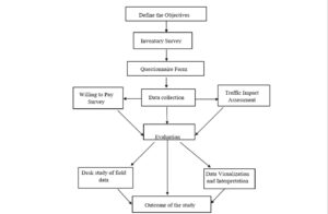
The conceptual framework of this study is designed based on the previous traffic impact assessment literature. The frame is started on reviewing previous literature and end with the outcome of this study. Field visit is for preliminary concept about study area which gives basic information in the locality. Inventory survey includes the important location in the locality and some opinion of the local people about the study area which helps to make final questioner survey form. The data collection is mainly based on the traffic survey and willing to pay survey. Finally, the survey data is analyzed and visualized. The final recommendation is based on the outcome of the study.
The traffic growth of any nation depends on the economic and cultural development of the nation. The economic development can be assessed from GDP, NSDP and PCI of the respective state or nation. The cultural development and population growth effect mainly the passenger traffic modes. The present analysis is concentrated on economic growth and population growth as main key parameter.
Traffic Condition in Bangladesh:
Analysis of state wise contribution of traffic flowing through the study area is important to analyses the impact of state growth on the traffic growth. Dhaka, Gazipur, Chittagong and Narayangonj states are identified as the major traffic contributing states on the present study area from number plate survey. The percentage of state wise traffic contributions are calculated from the data collected by conducting one day number plate survey on working day of a week and the data is presented in our Traffic Impact Assessment (TIA). The major passenger and goods traffic were contributed by Dhaka, Gazipur and Narayanganj states goods traffic contribution was more compared to Chittagong contribution.
Process of Traffic Impact Assessment (TIA):
Traffic Impact Assessment (TIA) is a valuable tool for assessing potential impacts of traffic generated by a proposed development to the surrounding transportation system. TIA generally includes a description of the scope and intensity of the proposed project, a summary of the projected impacts and any required improvements to ensure that the roadway facilities can safely accommodate the proposed development. The goal is to ensure that the transportation system will operate safely and efficiently within the design horizon of the study.
A well-prepared TIA helps the developer and permitting agency accomplish the following:
- Forecast the traffic impacts created by a proposed development by developing reasonable future traffic volumes for design purposes.
- Determine if improvements are needed to accommodate background traffic and the traffic from a proposed development.
- Allocate funds more efficiently.
- Relate land use decisions with traffic conditions.
- Evaluate the number, location, and design of access points.
- Update traffic data (projections).
- Provide a basis for determining the developer’s responsibility for specific off-site improvements.
When Is a Traffic Impact Assessment (TIA) Required?
Any development needs to have adequate infrastructure to support it, whether utilities or transportation. As a result, every proposed development requires an assessment of the adequacy of the site (e.g., compatibility with highway and municipal plans, access location(s), geometry, capacity, traffic control, etc. and any necessary improvements to safely accommodate the proposed development. In general, there are two levels of assessment that may be required in support of a development:
Comprehensive Report: used for larger development with significant traffic impacts or at complex location where the recommended improvements require a detailed analysis.
Memo Report: may be used for small development with low traffic impacts at simple location where the recommended improvements can be assessed in a memo format.

